Isle Royale National Park
Trip Assistant
How Much Time?
While it’s possible, this is not a daytripping park. It’s a backpacking destination. How much time you stay will likely be dependent on which transportation provider you use. The Ranger III departs Houghton, MI. The Isle Royale Queen IV departs Copper Harbor, MI. And the Voyageur II and Wenonah depart Grand Portage, MN. There are primitive cabins at Windigo and a lodge (and restaurant) at Rock Harbor. The Greenstone Ridge Trail, following the island’s spine, is just over 42 miles long, so you could spend quite a bit of time backpacking. Paddling is another option. There are inland lakes you can portage to or vast open water of Lake Superior. A few smaller islands also have campsites. It’s a great place, but takes some planning (and experience) to have a magical time.
Need to Know
- Isle Royale is the only park that closes for winter (November through April).
- The park is only accessible by ferry or seaplane. Ferries depart Houghton (MI), Copper Harbor (MI), and Grand Portage (MN).
- It’s primarily a backpacking/kayaking destination.
- The Voyageur II circumnavigates the island.
Highlights
- Boat Tours
- Ferry Rides
- Shipwrecks
- Mount Ojibway
- McCargoe Cove
- Daisy Farm
- Rock Harbor
- Windigo
Activities
- Hiking
- Backpacking
- Paddling
- Boat Tours
- SCUBA Diving
- Fishing
Favorite Trails
It’s a backpacking park, but you can hike Stoll Trail from Rock Harbor or Windigo Nature Trail at Windigo.
When To Go?
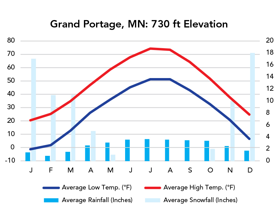
Weather
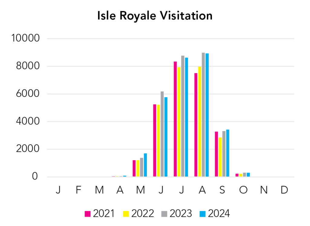
Visitation
Isle Royale is the only National Park that closes for winter. I like August/September when the weather’s nice, the trails are dry, and the bugs aren’t bad.
Park Map Downloads
Road Trips
Helpful Tools
Below you'll see a Google Map to help plan road trips from the east (Acadia), west (Voyageurs), and south (Indiana Dunes). It’s a good start, but I’d highly recommend making your own. Google My Maps, Wanderlog, Roadtrippers, and TripIt are incredibly useful trip planning tools. Find what works best for you!
There’s much more to our country. Here’s another Google Map with points of interest across all types of public land.
For campers, here’s a Google Map with National Forest campgrounds. National Park campgrounds are difficult to reserve (there are about 200!). With nearly 5,000 national forest campgrounds, you can usually pull in and find a spot.
If you like this, please check out my books or Buy Me a Coffee (more likely some fuel 🙂