Bryce Canyon National Park
Trip Assistant
How Much Time?
The park is fairly small with about 50 miles of hiking trails. I’m sure many come for less than a day and leave extremely satisfied.
I’d suggest spending at least one night. Mornings–even in the cold—are wondrous. That’s when you want to be hiking around the hoodoos. More time than that is fine, but with an early start, altitude acclimation, and reasonable fitness level, you can hike Peekaboo, Queens Garden, and Fairyland without much trouble. I’d also suggest hiking the entire Rim Trail back (it’s fantastic), but wouldn’t blame you if you hopped on a shuttle to take a well-earned break.
Need to Know
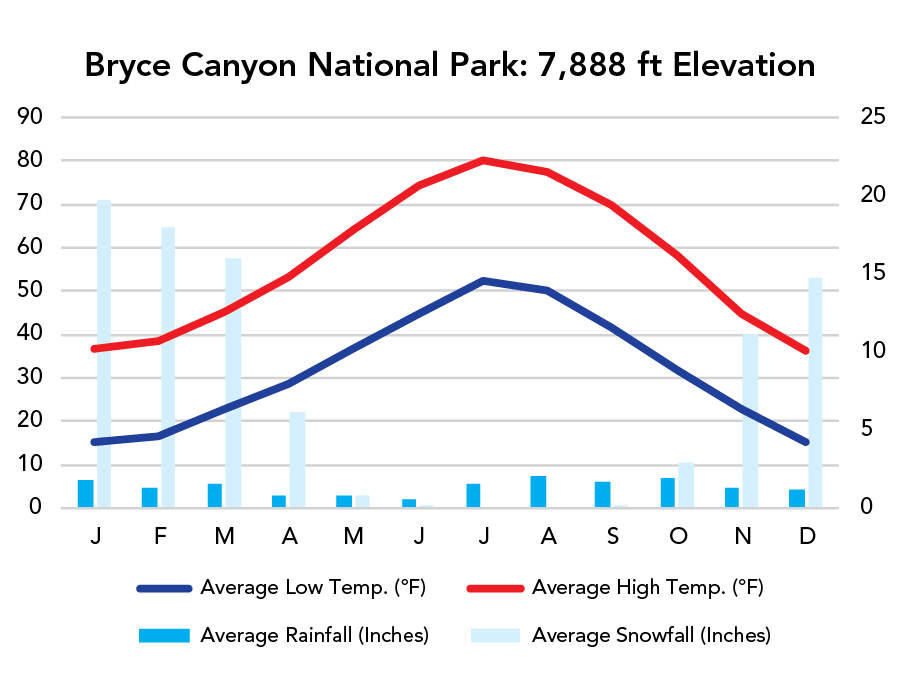
- It’s cooler here than nearby Zion or Capitol Reef because it’s higher elevation (about 8,000 feet). Travel in summer, and this will likely be your favorite Utah park. Not just because it’s spectacular but because it’ll be comfortable.
- Don’t rule out winter. Snow here is amazing. You just need to be prepared.
- Wall Street closes for winter. Yes, it’s great, but it’s not the only option.
- You’ll want to use the free park shuttle during peak season. This place gets uncomfortably crowded.
Highlights
- Inspiration Point (pretty steep)
- Bryce Point (somewhat steep)
- Sunset Point
- Fairyland Point
- Sunrise Point
- Paria View
- Yovimpa Point
Activities
- Hiking
- Backpacking
- Horseback Riding
- Biking
- Stargazing
Favorite Trails
Easy
Moderate Strenuous *Links to AllTrailsWhen To Go?
Weather
Visitation
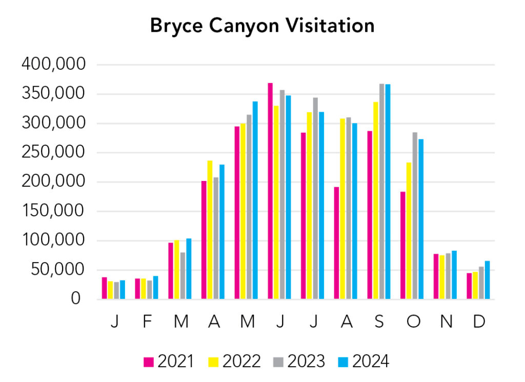
May through September is uncomfortably busy. Fortunately, there’s a free shuttle, but the whole idea of a shuttle is to get more people to already crowded areas. Bryce in snow is delightful, but, compared to the other Utah parks, it does get quite cold here in winter.
Park Map Downloads
Road Trips
Helpful Tools
Below you'll see a Google Map to help plan road trips from the east/north (Capitol Reef) and the west/south (Zion). It’s a good start, but I’d highly recommend making your own. Google My Maps, Wanderlog, Roadtrippers, and TripIt are incredibly useful trip planning tools. Find what works best for you!
There’s much more to our country. Here’s another Google Map with points of interest across all types of public land.
For campers, here’s a Google Map with National Forest campgrounds. National Park campgrounds are difficult to reserve (there are about 200!). With nearly 5,000 national forest campgrounds, you can usually pull in and find a spot.
Highlights
- Boulder Mail Trail (UT)
- Lower Calf Creek Falls (UT)
- Hole-in-the-Rock Road (Zebra, Peek-a-Boo, & Spooky slots, Jacob Hamblin Arch, Reflection Canyon, etc.) The only problem is Hole-in-the-Rock Road is unpaved and absolutely atrocious washboard. If you’re comfortable camping primatively, spend a few nights here.
If you like this, please check out my books or Buy Me a Coffee (more likely some fuel 🙂