Rocky Mountain National Park
Trip Assistant
How Much Time?
If you aren’t into hiking (or wandering around the touristy town of Estes Park), you don’t need much time. Driving Trail Ridge Road and Old Fall River Road is fantastic, but it only takes a day or so to thoroughly enjoy the sights. On the other hand, if you like to hike, there’s more than 300 miles of trails here. You could spend a few weeks and not get sick of these Rockies! Spend your first day driving Trail Ridge Road, taking it easy to get acclimated. After a night at elevation, start exploring the Bear Lake Area. Nymph Lake and Dream Lake are the easy options. Things get a little harder going to Sky Pond, Black Lake/Mills Lake, and Odessa Lake. Or you can go to summits, like Hallet Peak. If you’re ultra-fit and adventurous, cap your trip with a climb up to Longs Peak. If you’re fit but not that fit, hike to Chasm Lake for an exciting conclusion.
Need to Know
- During peak visitation, a timed-entry permit is required for Trail Ridge Road and/or Bear Lake Corridor.
- A timed-entry permit does not guarantee parking.
- Reservations required for camping except Longs Peak.
- Free shuttles connect Estes Park Visitor Center with Bear Lake, and spots in between.
- Acclimate to the elevation. The Bear Lake Trailhead is above 9,000 feet!
Highlights
- Bear Lake
- Longs Peak
- Trail Ridge Road (Rock Cut, Gore Range, Forest Canyon, etc.)
- Old Fall River Road
Activities
- Hiking
- Backpacking
- Rock Climbing
- Biking
- Horseback Riding
- Snowshoeing
Favorite Trails
Easy
Moderate Strenuous Extreme *Links to AllTrailsWhen To Go?
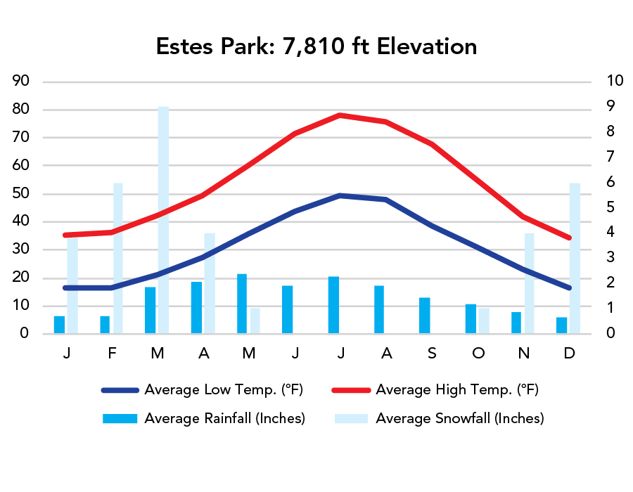
Weather
Visitation
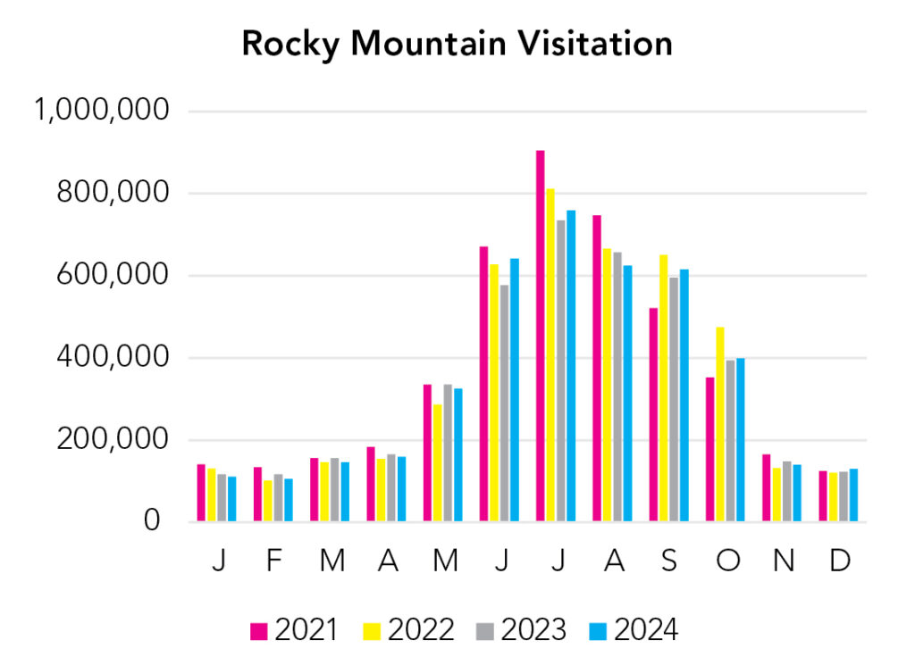
Summer and fall weekends are very busy. The park receives about the same number of visitors as Yellowstone but is just one-eighth the size. April and May can be good. Trails will be snowy. Lakes will be frozen. But mid-day temperatures are often nice, and the main trails are trafficked enough you usually don’t need any special equipment in the afternoon when the morning ice has thawed. Hiking poles can be helpful for stability. For peak season travel, you really want to try to be here mid-week, even then it will be busy. Timed-entry helps getting into the park, but a lot of people wake up before the timed-entry period, making securing parking at some of the most popular trailheads even more difficult. There is a park shuttle to Bear Lake. Also, Bear Lake Trailhead is at more than 9,000 feet elevation. Elevation in the park varies from 7,600 feet to 14,259 feet (Longs Peak), and temperature drops 3-5°F with every 1,000 feet of elevation gain.
Park Map Downloads
Road Trips
Helpful Tools
Below you'll see a Google Map to help plan road trips from the east (Gateway Arch), north (Grand Teton), west (Great Basin), and south (Great Sand Dunes). It’s a good start, but I’d highly recommend making your own. Google My Maps, Wanderlog, and TripIt are incredibly useful trip planning tools. Find what works best for you!
There’s much more to our country. Here’s another Google Map with points of interest across all types of public land.
For campers, here’s a Google Map with National Forest campgrounds. National Park campgrounds are difficult to reserve (there are about 200!). With nearly 5,000 national forest campgrounds, you can usually pull in and find a spot.
Highlights
- Green River Lakes Recreation Area (WY)
- Cirque of the Towers (WY) / (Bridger-Teton NF)
- Medicine Bow Peak (WY) / (Routt-Medicine Bow NF) (It's less steep going from the other side, Lake Marie.)
If you like this, please check out my books or Buy Me a Coffee (more likely some fuel 🙂