Zion National Park
Trip Assistant
How Much Time?
It’s almost impossible to give a general amount of time for a visit. Some people spend most of their lives here. Others enter Zion-Mount Carmel Highway in the middle of peak visitation and they can’t wait to get out.
There are about 50 miles of trails here. However, the big draw is canyoneering. There are many narrow canyons hidden within the park’s boundaries. The Narrows most people hike, which is an absolute riot, is very wide compared to the slots thrill seekers play in.
So, how much time? The typical trip is hike The Narrows and Angel’s Landing and move on to the next stop. While possible to do them both in a day, it’s probably better to stretch it out to two. Note that a permit is required for Angel’s Landing (a ranger typically checks them at Scout Lookout). And, if you’d like to hike The Narrows beyond Big Springs (or thu-hike it from the top down), you’ll need a permit.
There’s quite a bit more to do. You’ll find easily accessible slot canyons on either side of Zion-Mount Carmel Tunnel. The Subway (permit required) and West Rim are exceptional hikes. And Kolob Canyons is the park’s quiet corner.
Need to Know
- While Zion doesn’t require a timed-entry permit, many of the park’s most popular activities do. Angel’s Landing does. The Narrows (to hike beyond Big Springs, thru-hike top-down, or overnight) does. Left Fork/Subway does.
- Reservations required for camping.
- The park can be remarkably busy. And it doesn’t really let up until November through February.
- Winter can be a fantastic time to visit. You can drive Zion Canyon Scenic Drive on your own (except popular holidays/weeks). And daytime highs are usually surprisingly comfortable.
- If you’re lucky and catch some snow/rain, ephemeral waterfalls accent the canyon’s walls!
- Parking fills pretty quickly at the visitor center. You can also park in Springdale, and then hop on a different shuttle line that will ferry you near the visitor center.
- You can also bypass the Zion Canyon Shuttle by hiking/biking Pa’rus Trail or spending the night at the park lodge.
Highlights
- Zion Canyon Scenic Drive
- Zion-Mount Carmel Highway
- Kolob Terrace Road
- Lava Point Overlook
- Kolob Reservoir (cool in summer)
- Kolob Canyons
Activities
- Hiking
- Backpacking
- Horseback Riding
- Biking
- Paddling
- Rock Climbing
- Canyoneering
Favorite Trails
Easy
Moderate Strenuous- Mouth of the Narrows (can go to Big Springs)
- Left Fork/Subway
- West Rim
- East Rim
- Kolob Arch
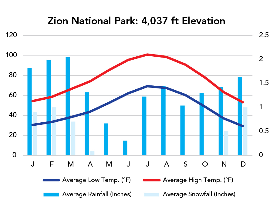
When To Go?
Weather
Visitation
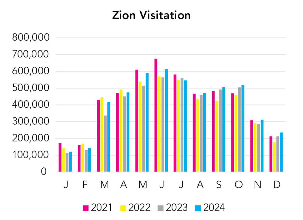
Zion is one of the busiest national parks in the country and it feels like it when you drive through Zion-Mount Carmel Highway. The good news is the park shuttles do a good job of getting people around and expanding parking space. The bad news is, shuttles deliver more people to already crowded areas. The only way to escape the crowds is to visit in January or February. It’s usually pretty cold then, but not so cold you can’t have a good time.
Park Map Downloads
Road Trips
Helpful Tools
Below you'll see a Google Map to help plan road trips from the east (Bryce Canyon), north (Great Basin), west (Las Vegas, NV), and south (North Rim, Grand Canyon). It’s a good start, but I’d highly recommend making your own. Google My Maps, Wanderlog, and TripIt are incredibly useful trip planning tools. Find what works best for you!
There’s much more to our country. Here’s another Google Map with points of interest across all types of public land.
For campers, here’s a Google Map with National Forest campgrounds. National Park campgrounds are difficult to reserve (there are about 200!). With nearly 5,000 national forest campgrounds, you can usually pull in and find a spot.
Highlights
There’s a ton of National Forest and BLM land. The Arizona Strip is great, and Cedar Breaks is nice place to cool down when it’s too hot at Zion. Kanara Falls, also good. Cottonwood Canyon (unpaved) is a beautiful route to avoid the Bryce-Zion traffic.
If you like this, please check out my books or Buy Me a Coffee (more likely some fuel 🙂