Haleakala National Park
Trip Assistant
How Much Time?
If you’re headed up the volcano for sunrise, know that it will be cold. Be prepared for it, so you want to stick around for the afternoon (hiking Sliding Sands Trail). If you need some beach time after that, I get it, go for it. The next stop is Kipahulu. It doesn’t take long to get there on the unpaved-car-rental-agreement-breaking stretch of road going counterclockwise around Haleakala. Take Hana Highway, and it’ll take a while, likely a full day, and you’re way better off spending a night at Hana to break up that very stressful drive. Kipahulu doesn’t take much time either. It’s one hike: Pipiwai to Waimoky Falls.
Need to Know
- A permit is required for several 4x4 roads, including the popular White Rim Road. Fill up with gas before heading out on the dirt roads and be prepared for self rescue.
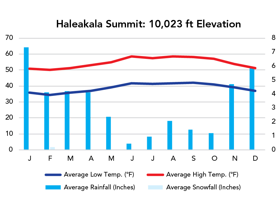
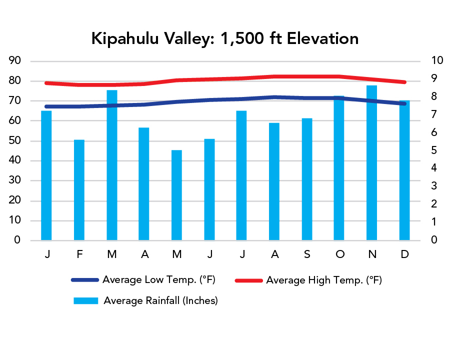
- Haleakala reaches 10,023 feet. Kipahulu is basically at sea level. Temperature decreases 3-5°F with every 1,000 feet of elevation gain.
- Piilani Highway (Hwy 31) is quite nice, but I don’t make the rental car company agreements.
Highlights
- Haleakala Summit
- Kalahaku Overlook
- Pa Kaoao Overlook
- Haleakala Summit Viewpoint
- Hosmer Grove
- Waimoku Falls
- ‘Ohe’o Gulch
Activities
- Hiking
- Backpacking
- Biking
- Stargazing
- Swimming
- Birdwatching
When To Go?
Weather
Weather
Visitation

Visitation is pretty steady year-round and weather is similarly stable. I’d try to travel with the whales, which are abundant from winter into spring. Another thing to think about here is how Maui receives about 2.5 million annual visitors. The island is about 465,000 acres. The Big Island is 2,573,000 acres and receives about 2 million annual visitors. Cram a whole lot of those visitors on the narrow winding roads of Hana Highway or Kahekili Highway and it’s not exactly the vacation paradise you’ve been dreaming about. There are two ways to solve this: money or knowledge. I’d put a fair amount of time into figuring out what to do on your Hawaiian vacation. I’m happy to help as much as I can.
Park Map Downloads
Road Trips
Helpful Tools
Below you'll see a Google Map to help plan a Maui trip. Much is made about the road around Haleakala and how driving it will void your rental car agreement. That's likely true, but the road is usually quite nice and it saves you all kinds of headaches getting through Hana Highway, which has extremely limited parking at the most desirable destinations. It’s a good start, but I’d highly recommend making your own.
Google My Maps, Wanderlog, and TripIt are incredibly useful trip planning tools. Find what works best for you!
There’s much more to our country. Here’s another Google Map with points of interest across all types of public land.
For campers, here’s a Google Map with National Forest campgrounds. National Park campgrounds are difficult to reserve (there are about 200!). With nearly 5,000 national forest campgrounds, you can usually pull in and find a spot.
Highlights
- Hookipa Beach (turtles and windsurfing)
- Honomanu Falls
- Waianapanapa SP
- Kaihalulu Beach
- Makena (Big) Beach
- Wailea Beach
- Black Rock Beach
- Honolua Bay
- Waihee Point
If you like this, please check out my books or Buy Me a Coffee (more likely some fuel 🙂