Joshua Tree National Park
Trip Assistant
How Much Time?
I could spend days wandering around aimlessly enjoying all the different Joshua Trees and whacky rocks. For others an hour or two is plenty.
I’d set driving Park Boulevard, stopping wherever you’re compelled to stop and hiking Boy Scout Trail to Wonderland of Rocks (just beyond Willow Hole) as your mandatory itinerary.
There’s about 65 miles of trails here, and some serious 4x4 roads, so you could spend an action-packed week here too. Regardless, be sure to spend at least one night. This place provides some of the best sunrises/sunsets.
Need to Know
- Reservations required for most campgrounds.
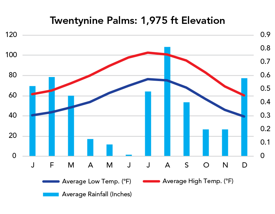
- It’s busy fall through spring. Summer’s hot, with comfortable mornings.
- Water is only available at Cottonwood, Black Rock, Indian Cove Ranger Station, West Entrance Station, and Oasis Visitor Center. Come prepared.
- The most easily-accessible Joshua Trees are found between the intersection of Pinto Basin Road and Park Boulevard and the Joshua Tree (West) Entrance Station. There are many great spots.
Highlights
- Park Boulevard
- Indian Cove
- Keys Ranch
- Geology Tour Road
- Keys View
- Hall of Horrors
Activities
- Off-Roading
- Hiking
- Backpacking
- Rock Climbing
- Horseback Riding
- Biking
- Stargazing
Favorite Trails
Easy
- Hidden Valley
- Split Rock
- Arch & Heart Rocks
- Skull Rock
- Keys View
- Cap Rock
- Cholla Cactus Garden
- Barker Dam
- Boy Scout (to Wonderland of Rocks)
- Hall of Horrors
- Lost Palm Oasis
- Lost Horse Mine
When To Go?
Weather
Visitation
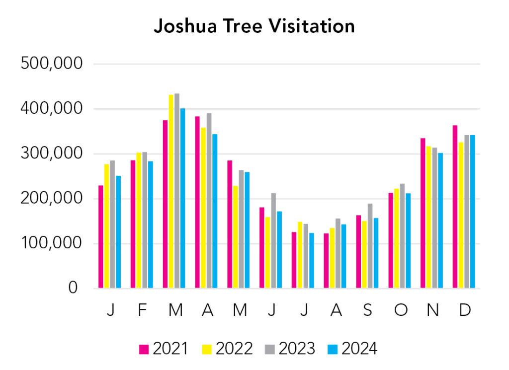
Fall through spring is the busy season here, but summers can be nice (in the morning). And you might want to consider a summer trip because Joshua Tree visitation has really exploded in the last decade.
Park Map Downloads
Road Trips
Helpful Tools
Below you'll see a Google Map to help plan road trips from the east (Saguaro), north (Death Valley), west (Channel Islands), and south (Mexican Border). It’s a good start, but I’d highly recommend making your own. Google My Maps, Wanderlog, and TripIt are incredibly useful trip planning tools. Find what works best for you!
There’s much more to our country. Here’s another Google Map with points of interest across all types of public land.
For campers, here’s a Google Map with National Forest campgrounds. National Park campgrounds are difficult to reserve (there are about 200!). With nearly 5,000 national forest campgrounds, you can usually pull in and find a spot.
Highlights
I don’t know this area. Was 100+°F last time out there, so hustled through.
If you like this, please check out my books or Buy Me a Coffee (more likely some fuel 🙂