Grand Teton National Park
Trip Assistant
How Much Time?
There’s over 200 miles of hiking trails here and anything penetrating this magnificent mountain range is great, so you could spend a week or two and probably not get sick of it.
If you only have a day, I’d get an early start and spend all of it around Jenny Lake. There are hikes of every difficulty level imaginable here.
With more time, then you start thinking about spending a day at Jackson Lake and/or driving around to the other side of the range to hike Alaska Basin or Table Mountain from Caribou-Targhee National Forest. Most people do Alaska Basin as a lollipop, but you can continue through the park, exiting at Phelps Lake via Death Canyon. Even if you don’t love hiking, treating the Tetons as a pit-stop to/from Yellowstone is a bad idea. Spend at least one night to enjoy sunrise/sunset in this incredibly special place.
Need to Know
- The park is very busy in summer. 95% of visitors arrive between May and October.
- If you visit in summer, get an early start. Trailhead parking fills early.
- The offseason can be good. Hiking is slightly more treacherous, but seeing this range covered in snow is fantastic!
- The Lake Solitude Loop is better counterclockwise (IMO).
- There are two parking areas at Schwabacher Landing. Both are excellent.
Highlights
- Moulton Barns
- Schwabacher Landing
- Teton Park Road
- Snake River
- Teton Point Turnout
- Chapel of the Transfiguration
- Cunningham Cabin
Activities
- Hiking
- Backpacking
- Boating
- Biking
- Horseback Riding
- Rock Climbing
- Mountaineering
- Fishing
- Cross-country Skiing
- Snowshoeing
Favorite Trails
Easy
- Jenny Lake Loop
- Leigh Lake
- Menor’s Ferry
- Taggart Lake
- Cunningham Cabin
- Lake Solitude Loop
- Amphitheater Lake
- Table Mountain (N. Teton)
- Garnet Canyon
- Alaska Basin
When To Go?
Weather

Visitation
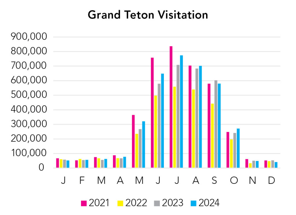
Summer is extremely busy, especially for a relatively small park. It’s also the best time to hike (but not the only time).
Park Map Downloads
Road Trips
Helpful Tools
Below you'll see a Google Map to help plan road trips from the east (Wind Cave), north (Yellowstone), west (Crater Lake), and south (Capitol Reef). It’s a good start, but I’d highly recommend making your own. Google My Maps, Wanderlog, Roadtrippers, and TripIt are incredibly useful trip planning tools. Find what works best for you! (I can't update this map until some roads open for the summer.)
There’s much more to our country. Here’s another Google Map with points of interest across all types of public land.
For campers, here’s a Google Map with National Forest campgrounds. National Park campgrounds are difficult to reserve (there are about 200!). With nearly 5,000 national forest campgrounds, you can usually pull in and find a spot.
Highlights
The Wind River Range (Bridger-Teton and Shoshone National Forests) is undeniably one of the most beautiful mountain ranges in our country. However it's not particularly accessible. You can take a long, unpaved road to Green River Lakes, which is spectacular or you can enjoy a few mediocre viewpoints from paved Skyline Drive. The best thing to do is to backpack among these prominent peaks (including the tallest peak in Wyoming). Cirque of the Towers is the most notable destination, but it's not the only one. Heck, if a busy backpacking route isn't your thing, you can make one turn along the way at Big Sandy Lake and walk toward Haystack Mountain and Temple Lake and leave those crowds behind ... but remember, the crowds here are nothing like you'll find at Grand Teton National Park (although you'll still find people complaining about people here).
- Craters of the Moon NM (ID)
- Sawtooth NF (ID)
- Lake Owyhee SP (OR)
- Succor Creek State Natural Area (4x4) (OR)
- Leslie Gulch (4x4) (OR)
- Chief Joseph Scenic Byway (WY)
- Bighorn Canyon NRA (WY/MT)
- Bighorn National Forest (WY, fantastic hiking/backpacking destination)
- Devil’s Tower NM (WY)
- Jewel Cave NM (SD)
If you like this, please check out my books or Buy Me a Coffee (more likely some fuel 🙂