Great Basin National Park
Trip Assistant
How Much Time?
If you only spend a day, hikers will likely have to choose between Wheeler Peak or Bristlecone Grove. And you’ll have to make sure you’re acclimated to the elevation for either of them.
Or spend a couple nights, enjoy the stars, summit Wheeler Peak, explore the Bristlecone Grove, and then tack on the loop around Baker and Johnson Lakes. Add in a cave tour and you have yourself a nice little national park trip here!
But, I’m sure you get it. The park isn’t that big. There’s only about 65 miles of trails. You don’t need a lot of time here.
Need to Know
- While visitation is light by most western National Park standards, campgrounds and cave tours fill regularly.
- The final nine miles of Wheeler Peak Scenic Drive closes for winter.
- If planning to summit Wheeler Peak, snow often sticks around into summer.
- There are a few 4x4 roads, unlocking corners of the park that few visitors take the time to see.
- Respect the bristlecones. Some have been living there for 1,000s of years.
Highlights
- Mather Overlook
- Lehman Cave
- Wheeler Peak Overlook
- Great Basin Visitor Center
- Snake Creek
Favorite Trails
Easy
Moderate Strenuous *Links to AllTrailsWhen To Go?
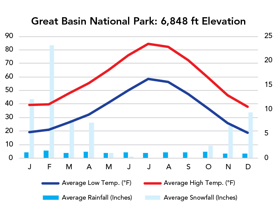
Weather
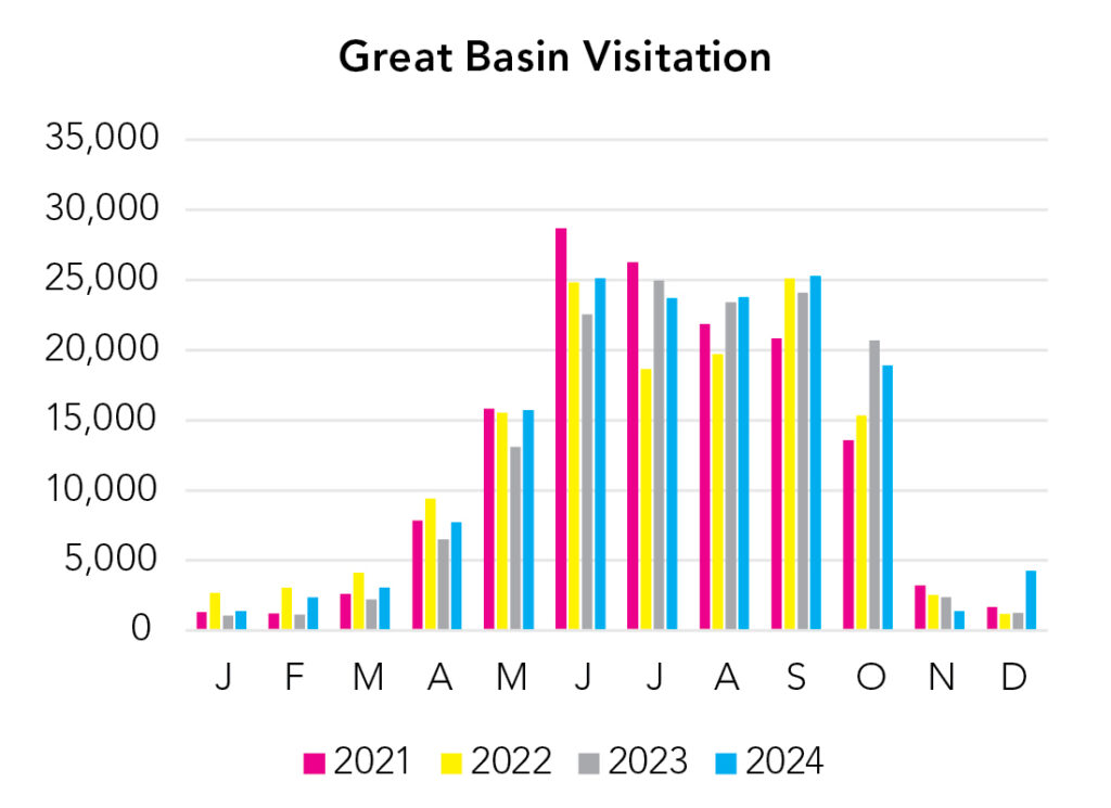
Visitation
You can get in the cave year-round, but hiking to the summit of Wheeler Peak is predominantly done in summer (and snow will still be up there into June, if not later). It’s a little bit of a tricky park to add to national park itineraries due to it’s remote location, high elevation, and the closest parks being mostly desert. I’d go in summer and check out the mountains in northern Utah (specifically the Uinta Range) as well or you could hustle over here from Yosemite, but, if you’re doing that, the Eastern Sierra is right around the corner, and that’s an even better choice if you haven’t been there yet.
Park Map Downloads
Road Trips
Helpful Tools
Below you'll see a Google Map to help plan road trips from the east (Uinta Mountains), west (Yosemite), and south (Las Vegas, NV). It’s a good start, but I’d highly recommend making your own. Google My Maps, Wanderlog, Roadtrippers, and TripIt are incredibly useful trip planning tools. Find what works best for you! (Northern Nevada is a mystery to me.)
There’s much more to our country. Here’s another Google Map with points of interest across all types of public land.
For campers, here’s a Google Map with National Forest campgrounds. National Park campgrounds are difficult to reserve (there are about 200!). With nearly 5,000 national forest campgrounds, you can usually pull in and find a spot.
Highlights
I left the north route off because I have no clue what’s up there. I know it’s all high elevation, and southern Idaho is pretty great, and that Oregon/Idaho/Nevada corner is amazing, but northern Nevada is a complete mystery. It is almost entirely federal land though, so, if you're looking for solitude, you'd have a hard time choosing a more remote region.
If you like this, please check out my books or Buy Me a Coffee (more likely some fuel 🙂