Redwood National Park
Trip Assistant
How Much Time?
Driving through on the US-101 and Newton B. Drury Scenic Parkway won’t take you long. But there are about 200 miles of hiking trails to explore. One night is enough to see the highlights. Just know you need a permit to get to Gold Bluffs/Fern Canyon (or enter outside permit hours). You definitely want to go to Tall Trees. That requires a permit whenever you’d like to go. There are good alternatives for the permitless among us. You can hike to Fern Canyon via James Irvine and Miner’s Ridge Trails. And there are plenty of tall trees at Lady Bird Johnson Grove, Stout Grove, Boy Scout Trail, and around Prairie Creek.
Need to Know
- A permit is required for Tall Trees.
- A permit is required for Fern Canyon during peak visitation.
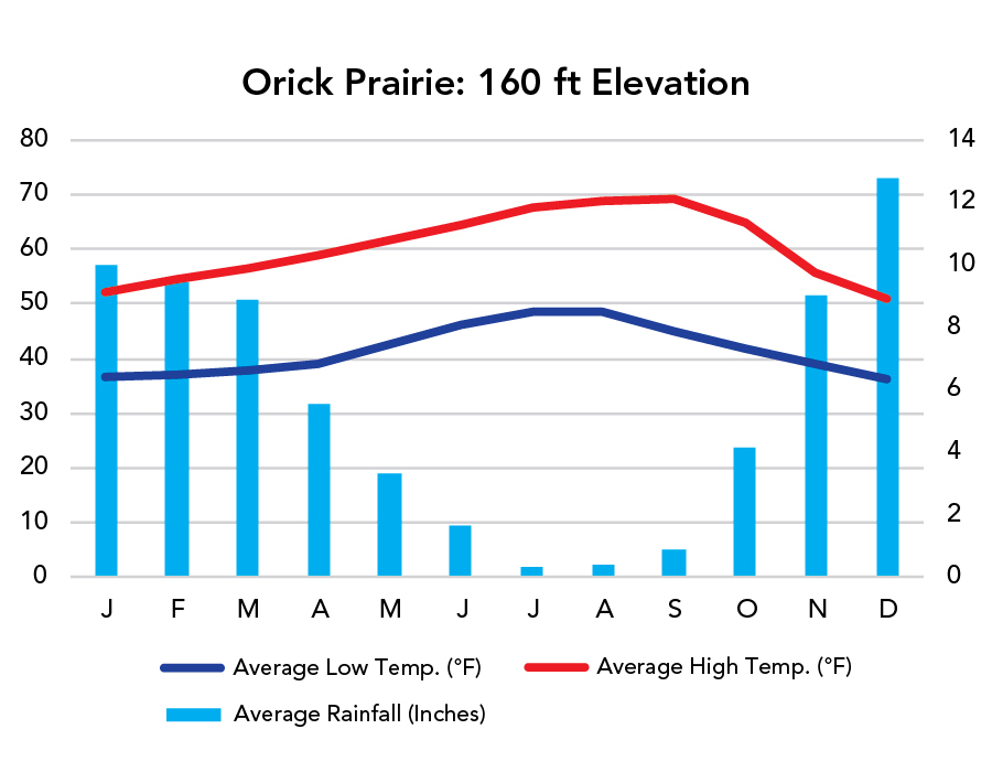
- Weather is comfortable year-round but foggy and wet (particularly in winter). Fog makes for a fairytale-like environment as long as the occasional ray of sun is able to poke through.
- Migratory birds fly through during spring and fall.
- There’s an $8 day-use fee for the State Parks, but park passes are accepted.
Highlights
- Newton B. Drury Scenic Parkway
- Cal-Barrel Road
- Gold Bluffs Beach
- High Bluff Overlook
- Howland Hill Road
- Big Tree Wayside
Activities
- Hiking
- Backpacking
- Biking
- Paddling
- Horseback Riding
Favorite Trails
Easy
Moderate Strenuous *Links to AllTrailsWhen To Go?
Weather
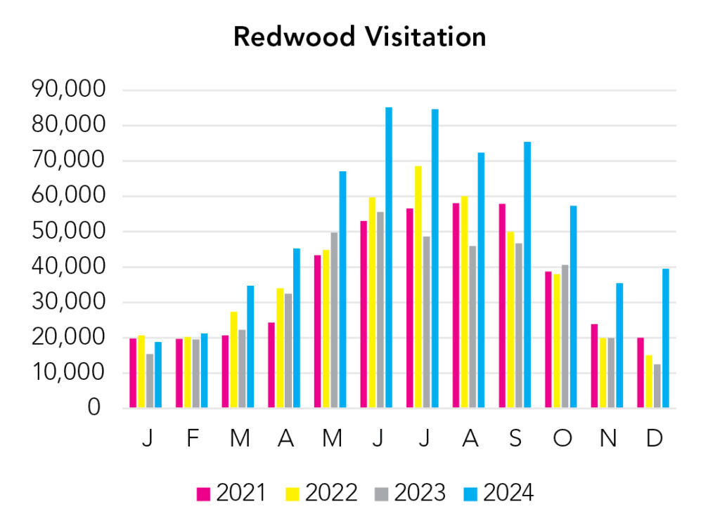
Visitation
Contouring the coast, Redwood is a pretty good place to go all year long. The big difference is winters are wet, summers are dry.
Park Map Downloads
Road Trips
Helpful Tools
Below you'll see a Google Map to help plan road trips from the east (Lassen Volcanic), north (Crater Lake/Pacific Coast), and south (Channel Islands). It’s a good start, but I’d highly recommend making your own. Google My Maps, Wanderlog, and TripIt are incredibly useful trip planning tools. Find what works best for you!
There’s much more to our country. Here’s another Google Map with points of interest across all types of public land.
For campers, here’s a Google Map with National Forest campgrounds. National Park campgrounds are difficult to reserve (there are about 200!). With nearly 5,000 national forest campgrounds, you can usually pull in and find a spot.
Highlights
- Mount Shasta (CA) / (Shasta-Trinity NF)
- McCloud Falls (CA) (Three separate falls)
If you like this, please check out my books or Buy Me a Coffee (more likely some fuel 🙂